I am beginning to think someone has it in for me when I try to do some epic hikes, especially when in Arizona. It won’t stop me from trying though.
VIDEO
PHOTOS
New Album
As I get closer to the big 5-0 I wanted to do a more rugged multi day trip. After researching I decided to backpack in the Chiricahua Mountains of South Eastern Arizona. Rugged, yep. Remote, check. Challenging? Absolutely.Another reason for this was to spend some extra time with Mackenzie as my base of operations would be Tucson. Win-Win right?
In the week leading up to my trip I start watching the weather. Lots of tropical storms coming out of the Pacific and going across Mexico touching off all kinds of flooding in the Southwest US. A few days before leaving I see that there is rain forecast for the area I will be in, Saturday and Sunday for sure. It’s hard to get accurate forecasts because where I am headed there are few weather stations. But it also looks like it will be cold and very windy.
This just means I have to add to my pack. Rain gear, bigger tarp with doors, warmer sleeping bag and additional warm clothes. Normally it would be in the 60’s I was going to be 40’s or lower. Not really happy about it but I can’t change my travel plans this late in the game.
This originally was going to be a solo trip, just me. Tracy talked me into having her tag along (not on trail) just to spend more time with Kiki and hell, to be out of Wisconsin again.
We had a very early flight on Thursday morning and we were in Tucson before 10 AM. Did some pre-hike errands and picked Kiki up after her class and went to lunch!
We hung out and Mackenzie stayed with us as she had no class on Friday.
On Friday morning I left around 8 AM and had an hour and forty-five-minute drive to get to the trail head. I was also planning on stopping at Johnny Ringo’s gravesite. If you’re not familiar with this particular ‘Cowboy’, the 1993 movie Tombstone brought his character from somewhat obscurity to infamy. His grave is on private property and the landowner is gracious enough to allow the public to come to the site. I thought it would be fun as it was on the same road as where the trail was.
When I pull up I see a cowboy. No, not just any cowboy, Johnny Ringo himself. I approach (cautiously, he’s going heeled). He asks me if I’m here for the vendetta ride. I politely tell him no. I have serendipitously came to the site on the one day of the year they are doing an event. This gentleman plays Johnny Ringo, in the city of Tombstone and other places. He shows me the site like a personal tour guide from beyond. We share a few movie lines and I am giddy like a kid on Christmas. After a few pictures handshakes and hat tips, I head down the road.


This
road, by the way, is dirt, 10 miles of dirt. In a rented Chrysler 300s.
Flashbacks to other trips.
This
is national forest or BLM land and is rugged as such, I drive for some time and
never find a sign. I turn around find a sign but no place to park. I find a
place to park but it’s not that close to the trail. I have no idea if I can
even park here. I get all my stuff ready put a note on the dash and walk to the
trail. I have not seen a person since Johnny.
Its
11 AM by the time I get to the actual trail. Mormon Ridge trail. It’s going to
be slow, I have over 3000 feet of elevation to gain. I think I am mentally
prepared for it. I think I am physically prepared for it. The temperatures are
mid 50’s and the sun is shining. So far so good.
There
are some ‘hitches’ to this whole trip. One is water. I can only carry so much
and there may or there may not be water in the springs I have mapped. People have
said last year’s snows were light and snow is really what feed springs. Because
of this uncertainty, I only allow myself to drink half my water for the trip
up. This way if I cannot locate water I have exactly half to get down. This
makes it tough as the climb is hard and I know I am expending much more energy
than I would coming down.

The
elevation going from 6200 feet to 9700 feet for a Midwesterner also plays into
the effort. I am just not used to the elevation.
I
know I may have mentioned that this is very rugged area. The trails are not
well maintained. I don’t even mean in the way that a crew comes and keeps them
from fallen trees and overgrowth. These trails see very little traffic at all.
At times I find myself having to really look for them, it’s just not obvious.
The
day goes by slow I am averaging under 2 miles an hour. But as I climb out of
the valley the views get better and better. All of the sudden a thunderous roar
can be heard and almost instantly 2 military jets (F16’s I think) come
screaming over the peak and down the canyon. It’s so loud its almost scary. I
tried to get a video of them but I was in some trees and the second time they
came around I was too late.
It
energizes me for a while. The adrenaline surge only lasts a little while and I
am back to a few hundred feet, take a break. Repeat.
About
2 pm I reach my first trail crossing. It’s not so much a crossing as a wore our
sign and a trail that goes in a different direction. I have GPS AND Map and am
glad for it. What I thought was a trail on GPS was a no go in real life and the
map showed me my other options. Thankfully I had options. Basically, a long
switch back that finally got me to the main trail at the ridge-line. The Crest
Trail. This is the best trail as it connects all the others at the top. It’s
the main artery to all the side and feeder trails.
The
plan this week was to camp near this trail and day hike to all the other peaks
in the area topping out at 9800 feet.
Feeling relived that the terrain will flatten out for me as I am near
the top I focus on water. I start looking for a side trail for the water.
Again, the trails as so faint and the signs are worn, fallen down, pointing
ambiguously or some combination of those traits.
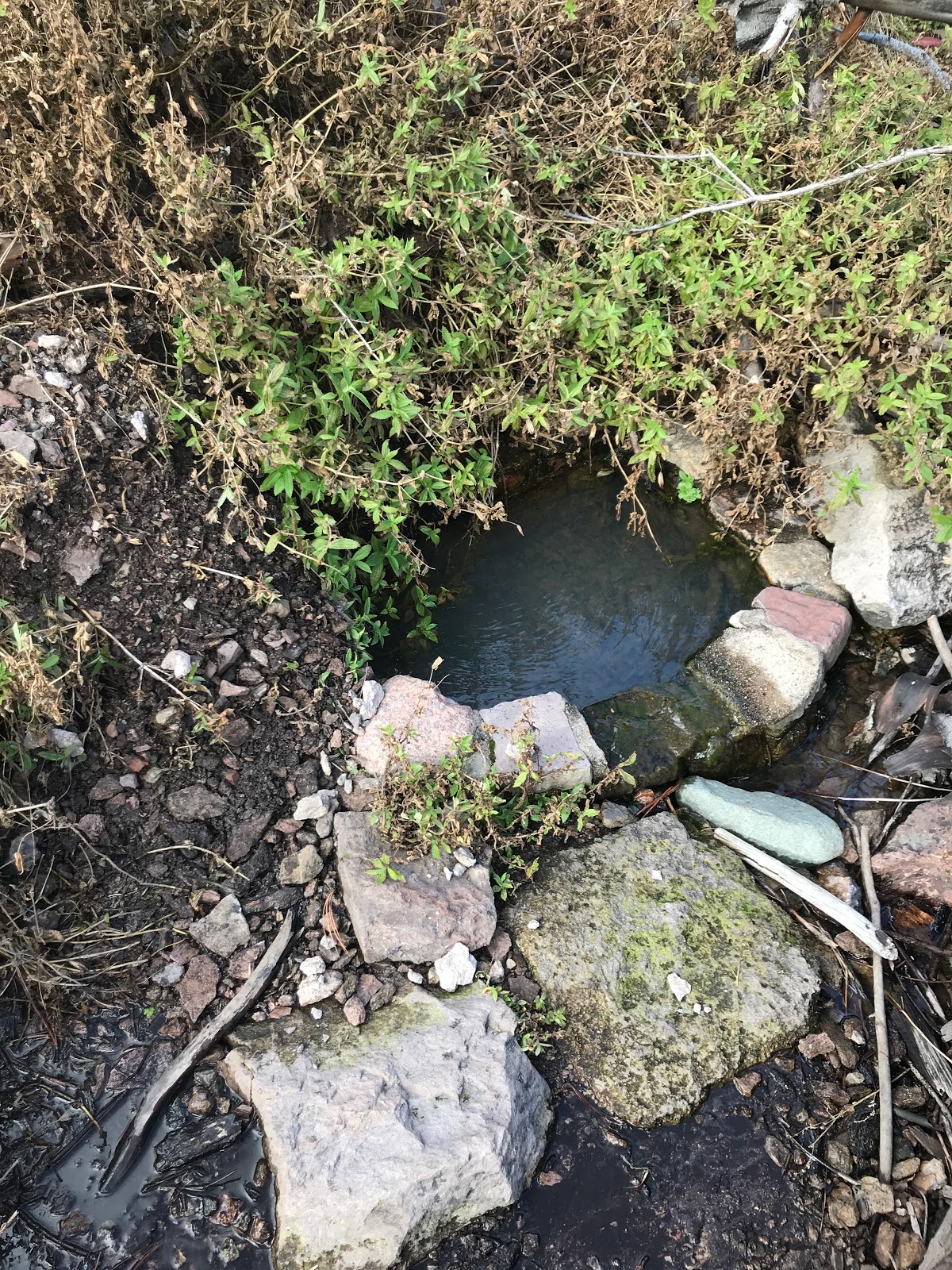
I
eventually find the Anita Park spring trail and start looking for said spring.
It’s a steep descent, so I shed my pack and decide to look for water without
it, no sense in dragging that around if there is nothing. Again, there are no
markers, just wilderness and downed trees. I point myself in the right
direction and listen. Shhhhhhhh….I hear a trickle. Just like meeting Johnny and
seeing jets, my adrenaline spikes. I work my way to it and see a small lovely
brick lined pool. It holds the water, fills up and trickles over. I am so
excited. I know I will be ok with water and my trip can continue.
I
hike back to my pack. Drink all the water I had. Then grab my empties and my
additional bladder and fill up on cold clear mountain spring water. Water is
life. I felt alive.
I
donned my pack now with over eight extra pounds of water. 134 ounces to be
exact. No one is going to be thirsty tonight. Plus, I would need it for
breakfast and coffee! No need to take less and have to make more trips for
water. A small penalty to pay.
Now
I had about 90 minutes to find a camp site before sun started setting. This is
another ‘hitch’ I am on a mountain. Flat sites for tents are rare and so I have
my hammock. No flat ground needed. Except the mountain has had had two separate
forest fires in the last 10-12 years. A lot of the large trees are gone. Even
of more concern is the dead ones still standing. I hiked until I found a
perfect spot. Flat and nice trees with very little dead still standing to be
concerned with. So far, the weather has been great, I am very optimistic,
however I know the forecast for rain and wind is supposed to hit at around 3 AM.
This
site had obviously been used by others as well, a rock fire ring was there and
a log for seating as well.
As
I set my hammock up the wind started picking up. I did my best to really batten
down the tarp the doors and fortified the stakes by putting rocks over them so
not to pull out in high wind. I finished unpacking, changed into some
comfortable clothes and ate the other half of a smashed subway sub I brought
for lunch. I did not bother with any other food and like every time I backpack,
I know I have brought way too much food.
I
hang my food bag. Yes, there are bears and mountain lions so I prefer to keep
my food as mine.
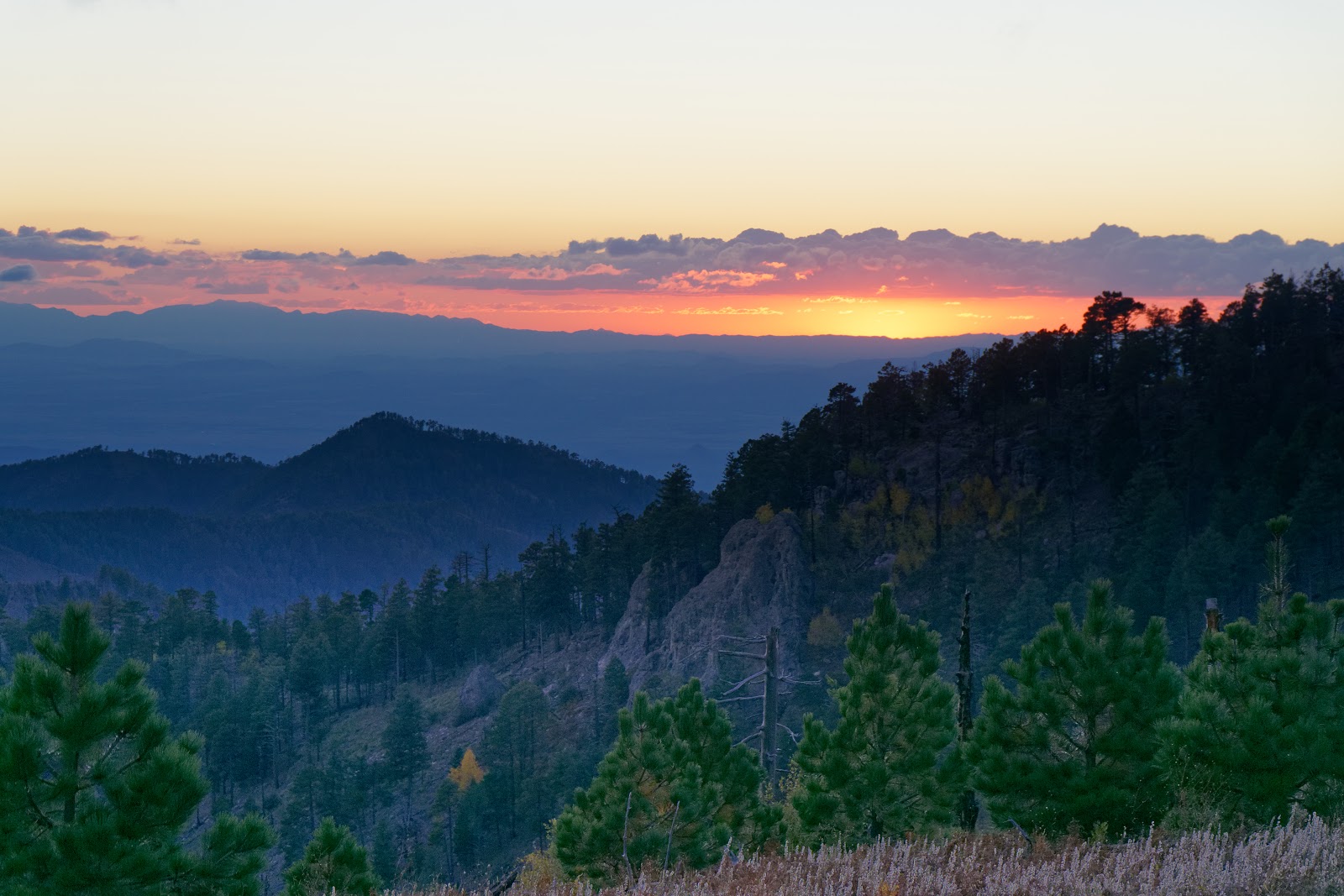
All
of the sudden I realize the sunset in incredible. I can see for miles and the
world just drops below me. The moon is up and all is good with me.

The
sun finally sets, and darkness settles in. It’s too windy to have fire and I
don’t want to be the cause of another forest fire on the mountain. Around 6:30
I settle into my hammock and pull out my Kindle. Another hiking luxury, but it
is so nice to just relax, read and eventually drift off to sleep.
It
doesn’t last long. Two hours later the wind really picks up. You can hear it
just roaring up the side of the mountain, then the sound stops then it hits my
campsite. At times I think I will certainly have the tarp ripped away, it’s
that bad.
I
fall in and out of sleep and around 10 I need to pee. I slip my shoes on and
step to the doors of my tarp. They are soaking wet. But it’s not raining? I
mean it’s wet on the inside and the outside. As I step through the door I turn
my headlamp on. Clouds. The clouds have settled on top of the mountain and are
staying put. I can see the finest of mist in the headlamp beam as if it were a
steam room. It permeates everything and there is nothing I can do. I am
thinking to myself with the wind so strong these clouds will get moved out by
morning. Wishful thinking indeed. I climb back to bed. The mist is held at bay
by my tarp and the netting on my hammock, so I stay mostly dry. It’s a night of
sleeping, waking to wind and eventually rain.
Only
once during the night did I have to fix a door that had been pulled free of its
stake from the wind. The flapping was like a tattered flag. I quickly got up to
fix it. I was rather pleased with myself as the rest of my set up held the rest
of the night.
Around
4 AM, I begin hoping the sun will be up in 2 hours the clouds will burn off and
I can dry out eat some breakfast and spend the day as planned. Again, I know,
based I a forecast I pulled with my satellite communicator, this weather is
here to stay.
The
time for sunrise happens but I can’t tell for certain. I remain warm and snug
but realize I can’t stay here forever. My hammock is so wet with mist it is
running from the netting and starting to soak into the main body where I lie. I
can feel it. At this point I could stay but it would be ‘less than optimal’ and
with not much to do but lay in bed, possibly get wetter and really set myself
up for some bad times. In my head I know what has to be done, but my heart is
not happy about it. Many months of planning and cutting my trip short by two
thirds. I mean I worked my ass off to get up here. I was not going to get to
enjoy it.
I
stripped out of my sleeping clothes, put on my rain paints and rain jacket and
went and grabbed my food bag. I wasn’t even going to have coffee. The wind and
rain were just to going to allow any of it. I had a protein shake (420 calories
in an 8 oz drink!) to get me started and I proceeded to breakdown camp.
Breaking
down in the rain sucks, breaking down when everything is wet and the wind is a
constant 20 miles per hour is a whole ‘nother level of suck. Leaving my tarp
for last to give me as much shelter as possible, I cram it into the stuff sack,
then squeeze it. So much water comes out, all I can do is laugh.
I
drink a lot more water, refill my bottles from the bladder of spring water.
Sadly, I dump 2 liters of it out as I won’t need it.
I
hoist my pack on my back. It is the heaviest it’s been. The water-soaked tarps
and such just add to the misery.
Determined
to make the trip a little more than an out and back, I decide to go down a
different way than I came up. The trail would pop me out almost the
same place I came in so, hey let’s see some different stuff.
I
begin my walk around 8 AM and its comical. The wind is so strong, the mist so
thick. It takes all the help my hiking poles can give to stay up right at times.
I
take the Crest Trail North until it meets Round Park and splits for Saulsbury
Canyon (my trail) or heads up to Fly Peak. Fly peak, one of the 6 or so peaks I
was supposed to get this weekend. Sigh.
Saulsbury
trail is not marked, it is faint (game trails are more worn) and it has not
been maintained in years. I decide to start counting the trees in the trail
that I have to circumvent, crawl under or climb over.
Despite
the howling winds and rain, I make pretty good time. Until I lose the trail.
All the trees down made me estimate where the trail was, in a general
direction. I lost the trail at least 4 times and had to bushwhack over what
might have been a trail or might just have been mountainside. I slip. I slide.
I twist and turn. Look at the map get a general bearing and keep walking. All
of the sudden there is trail again. I look behind, nothing. As if it was just
laid in front of me.
It’s
frustrating at worse, comical at best. Crossing talus slopes where no trail
would stay long anyway due to the nature of the rock itself, I continue and
point myself in what I deem to me the right direction and sometimes realize the
trail is now above or below me. How the hell? I know I am not the
only person when I find a fleece jacket snagged on some overgrowth. Someone
else with the fleece tied to or loosely tucked in a pack took the same ‘trail’
I did and left me a marker.
I
eventually get out of the clouds. Some blue sky in the distance but the mist
and wind still tendril down the mountain as if trying to bring me back.
At
this same time, I lose the trail for the last time. Some thoughtful hikers put
some cairns up but as I follow they abruptly stop. At this point it no longer
mattered. The map had the trail going up and around. I was pointed to the trail
just on a more direct route. Like a jaywalker I cut across, making my own way.
I spook 2 deer who just bound away, never even letting me ask for directions.
Deer can be such jerks.
On
my way down, the sun is out in full. Of course it is. At this time,
I half thought to just stop and camp for the day and salvage some of the trip.
Again, I was wary. I knew the weather was still looming. Showers, thunderstorms
more wind.
I
find what I call a little drainage cut and follow it down to meet the trail at
the end of my jaywalk. Like climbing down a large rock ladder. A few seeps of
water made it slippery. Difficult is a good word. I am testing every footfall
so as not twist or sprain or fall. It is a beautiful place but I don’t want to
have to be extracted. I reach the bottom and there it is. Nestled in some pines
and a carpet of needles, the trail! My little gamble paid off.
From
here on out the trail follows a small canyon. Its quiet and a small stream
appears. The trail crosses it several times. I come across a huge tree. I
decide to have fun and climb over this one. My tree count I started was now in
to the 80’s. I continue to follow the trail into a forest that
eventually turns into a field and then a vehicle path, a dirt parking lot. I am
off the mountain. I cross Turkey Creek one last time and see the car. I
end my walk at 103.

At
the car I get out of my rain pants. They are shredded. All the little slips,
sharp rocks and overgrowth have taken a toll on the nylon shell. I also have a
nice scrape on my right butt cheek, a huge bruise on my shin and cuts and scrapes
on my hands too numerous to catalog. A fun little motto of mine applies ‘No
good time comes cheap’. Be it monetary or physical it almost always seems to
play out that way.
I
change into a T and shorts for the drive home. As I stand half naked a car pulling
a pop-up camper comes up the primitive road. They ask me for directions to the
campsite. I tell them it’s further up the road (it is). It’s the first people I
have seen in 36 hours. I probably wouldn’t have seen anyone if I had stayed on
the mountain.
I
drive back to Tucson. I look back at the mountains. The clouds still sit atop
the peaks of the range. Nope, I made the right call.

It
rains or storms every day we are there. It’s very strange weather for the area,
everyone is telling us the same. It’s quite possibly due to the category 4
hurricane Willa that had just come off the Pacific and over Mexico. It just
could be my luck.