Pages

Saturday, December 21, 2019

NYC

Hey! Your favorite travel blogger is back. This time in the Big Apple, New York City.

As usual I was there for work, but all work and no play makes Jeff an even duller boy. Although 45th floor office views are not bad.


Due to delays I got in way too late to do much of anything on Tuesday. Wednesday I worked with meetings and such from 8 to about 3 and then I was finally on my own.

Got back to the hotel, changed clothes and off I went. Shortly there after I received a National Weather Service Alert for snow squalls.  And they were right, big heavy snow started falling within 10 minutes.

I had two options, standard Rockefeller Center stuff because it was close or get back on the train  downtown, to see that at night. I had just been there all day and did not feel like going back so I just went where I could walk.

The snow was flying, and some parts it was so crowded but other places it was almost ghost town.


I walked around, got a bite to eat and called it around 10:30. 

The next day I packed up, checked my bag with the bell hop and headed to Grand Central Station, where I picked up a real non-subway train in which to take me up to Fordham (Home of Fordham University). Where the New York Botanical Gardens are next door.

NYBG was running their annual holiday train show. This year the themed it with New York City landmarks. The buildings are built with foam board underneath and all natural materials on the outside. By all natural, I mean sticks and moss and bark, leaves and the like.  It was an incredible display and amazing craftsmanship.


After the train section, I checked out the conservancy which is much like the Mitchell Park Domes. Tropical forests, Desert and other floral displays, depending n the season.


When done I headed back to the city to get my stuff and head to the airport.  Last business trip of the year and always one of the most looked forward to.


Sunday, December 8, 2019

Mexico 2019

It had been a while since Tracy and I did a "us only" vacation. We had the vacation time and the points that we were able to go to Cancun in November. Leaving the early snow for some sun and warm temperatures if only for a little while.

Mackenzie had come home for a long weekend, since she wouldn't be here for Thanksgiving and her flight back to Arizona was the same day we left for Mexico. In fact her flight was 4 gates away and 45 minutes earlier than ours. Talk about great timing. 

Her flight left (at 5:30 AM) and then we boarded for the connection in Atlanta. Once there a short hour layover and off to Mexico we go.

We get off the plane and go through customs. The guys asked us 3 questions we said no and that was it. We looked at each other and shrugged, so much easier than last time here.

We had transportation waiting for us, because I took care of it before we left. no haggling no having 10 drivers try to get us a ride. 

Once at the hotel, we waited for our room, we met with the concierge to see what was available for things to do during the week. Scuba or snorkeling? Ruins? Catamaran trips and much more.

Once we got our room and bags delivered we stepped out on the balcony.


Yes,it is rainy season and we had clouds and rain for the first half of the week. We figured 'eh, tropical rain, comes and goes between the sun'.

Since it was a log day of travel, we walked to the grocery store to pick up a few items for the week (we had a studio villa). Grabbed a bite at one of the onsite restaurants and called it a day.

The next day we book a few excursions and spent the rest relaxing and drinking poolside. We get rained on and off but we didn't care. We made it an early night as we had full day as we booked a whole day visiting ruins and a Mayan village.

Our bus was there to pick us up at 7:00 am.  And it was pouring. 4 others from our hotel joined us. We then hit another hotel, but the couple there cancelled (no refund) and one more hotel for one other couple.  Our tour guide stopped at a convenience store and then asked if we were sure we wanted to do this. All this rain, all the walking. We all said yep and he exclaimed 'jesuschrist'. He then went into his explanation of what we would see and do. Stay away from some of the spicier foods, because he is Mexican-Chinese and so he can handle it but not us. He ended up being a great tour guide, wisecracking and really knowing his audience and how far he could go with his jokes.

The first place was over an hour drive away. The Oceanside ruins of Tulum.

So far the rain has held off.


Back in the van we head off to our next stop. The Jungle ruins of Coba. On the way the rain and thunderstorms pick up. Israel (the tour guide) apologizes, but doesn't because according to him they have been in a drought for some time and they really need all the rain we have had all week.

We get to Coba and get a little history and then we can explore. The main attraction is over two miles away so we rent two bicycles for about $4.  The rain has really picked up and so we put on our rain jackets (yes, we planned ahead). We ride to the 13 story temple and of course I am going to climb it. Slippery wet rock steps be damned. Tracy decided against it due to the rain and mostly her foot was getting quite sore with all the walking.

I make it to the top and all you see is jungle an occasional smaller temple in the distance.


Once down we bike back and get back on the van for the next stop. A Mayan village and a swim in a cenote.

The village is reminiscent of Old world Wisconsin, a replica of what life and rituals were for the Mayans who live(d) there. We were blessed (I guess, since I don't understand Mayan) we had a bite of typical fare and then onto swim in the cenote.

Nothing like a swim in an underground cave with bats. Honestly, it was pretty cool.

Our last stop was a afternoon meal of more traditional food, beans, squash, chicken, frybread.

Once fed we headed back to the hotel to end the day.

The rest of the week, we did a few more beach and pool days. Took the bus to get to a much better grocery store where we bought booze, bakery and some other items to get us through the week and not have to go to a restaurant all the time. Although we did that too. Plenty of tacos, table side guacamole, molcajete and tequila.

On Friday night we had tickets to the Cirque du Soleil show Joya. Again, a long bus ride to the theater situated in the jungle. If you have been to a Cirque show you know what it is all about. Theatrical feats of amazing humans.

Finally, on Monday we took a ferry to Isla Mujeres. We did this last time and it was a blast so we had to go back. We rent a golf cart and drive all over the island. See the eastern most point of Mexico, a Jamaican bar with some of the best ceviche I have ever had.  From there a turtle farm and more beach time at Playa Norte.


We watch a beautiful sunset on the dock as we wait for the ferry to take us back to the mainland.

The next day we have a late flight out so it's one final morning of sun and relaxation.  Adios Mexico, until next time.

SEE ALL THE PHOTOS HERE


Friday, August 30, 2019

Welcome back to the trip report travel blog!

First, a little background for this trip. My friend Mike had moved out to Colorado and over the last few weeks I had been listening and watching the videos from his recent forays in backpacking. Mike has done some backpacking with me in Arizona and in Minnesota and now he was working his way through the Colorado Trail that has a starting point almost in his backyard.

The Colorado Trail is a nearly 500-mile trail that traverses a large swath of the Rocky Mountains, starting in Denver and ending in Durango. It also shares some of its path with the Continental Divide Trail, a 3100-mile trek from Mexico to Canada along the Rocky Mountain range.

The Colorado Trail is divided into 32 sections and so far, Mike has done 1 through 5. We got to talking and I casually asked If he would mind some company in the future. By future I meant within the next few weeks as my window of opportunity would be very short, with school starting and then the weather getting colder in the mountains.

Mike was a little reluctant at first, nah, of course he would be happy to enjoy some company on his next trip. It was then we got to the planning. We agreed that sections 6 and 7 would be the logical choice. Because Mike has seen 1-5 twice (he has to double back with no shuttle) and this was the next closest and probably easiest to do car shuttle.

6 and 7 would take us about 47 ‘map’ miles. We figured we would need 3 nights to do it enjoyably with not killing ourselves. Mike took the honors of figuring our approximate daily distances, as well as shuttle positions. While he did that, I busted out some free airfare, courtesy of some points I had and it was on!

It was only 3 weeks away and as it grew closer, I stepped up my cardio by running every other day, even getting Joel to sign up with me for a 13K trail run. Heart and legs ready, my only worry was the altitude. I would have a day to acclimate to 10,000-12,000 ft of altitude.

Day Zero

Wednesday morning, I flew to Denver, where Mike picked me up and we dropped all my stuff at his place.

From there he took me directly to Red Rocks (also the music theater) for what else? A hike. We figured anything at elevation higher than what I was living at would be a good start and this got us up over 7,000’. No one tells you but Denver is very warm in the summer, we did this 7+ mile hike in 90° heat. Which made it all the tougher. This is Mikes hiking training ground as it is literally a few minutes from his place. He’s very lucky because it is a very pretty place to play.


We earned some DQ blizzards for our efforts.

From there we went back to Mike’s cleaned up, changed and did a few pre trip errands (Grocery and REI). From there we ended the day as with some pizza and beer.

Day 1 (8/1/19) And it Starts

One of the cool parts of this trip is Mike owns two cars so we can shuttle and leave one at the beginning and the end and not have to worry about expensive shuttle services or unreliable ride shares. The not so cool thing is, one of the cars he owns is a first gen Mazda Miata. It becomes a little under-powered with the thin air. Oh yea, there is not much of a trunk in that thing. No Backseat either. I had to ride shotgun with a backpack on my lap for 45 minutes. Mike thought this was pretty damn funny.


With the cars dropped we were finally ready to hit the trail. It was about 2:00 PM when we started. Kenosha Pass 10,0000 ft elevation.


The plan was to do about 8 miles today, a short day but with a late start it would be fine. Plus, it would help with my acclimation.

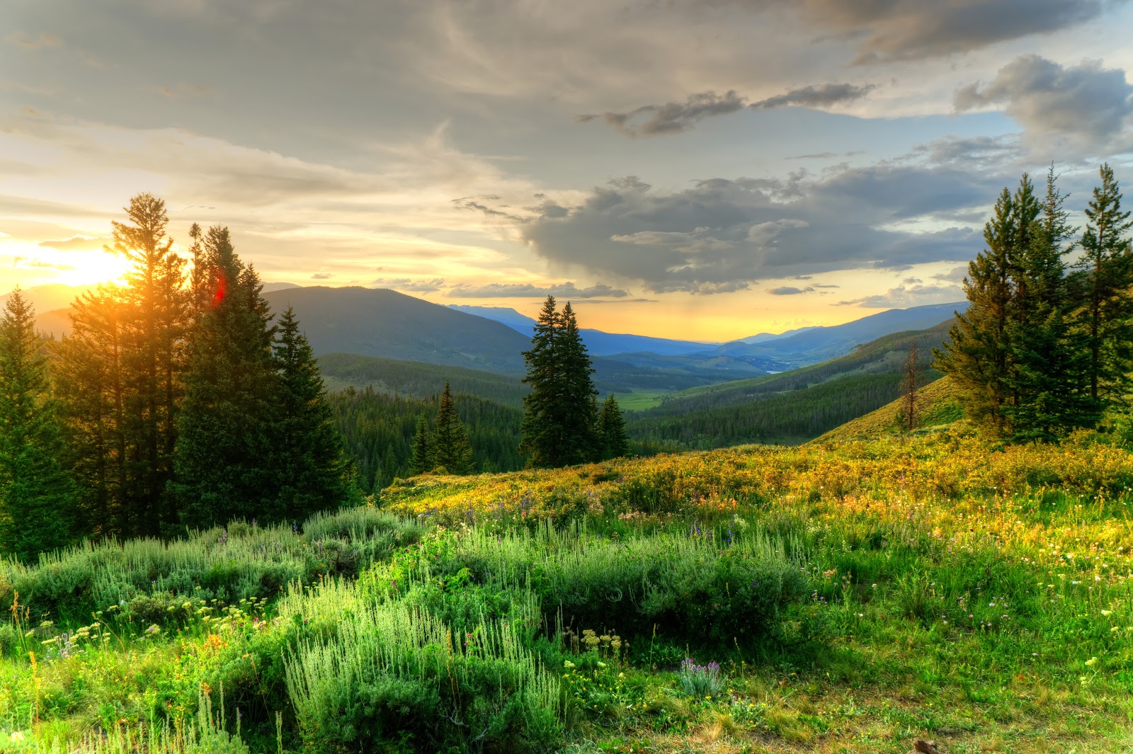
As we start it’s hard not to notice some of the clouds. As is with the Rocky Mountains the afternoons can be prone to thunderstorms. That and I was on the trail. I do have a knack for rain when hiking.

We aren’t but a mile or two in and the sprinkles start. Then stop, then thunder, then sprinkles then it stops again. I stop to put the rain cover on my pack. That should appease the rain gods and stop this on and off showers.

Nope. About 30 minutes later it starts to pour. Big, heavy, plunking drops. It rains enough to soak my hat so that the water runs off the brim like a roof. We tough it out and decide we don’t need any other rain gear for the time being. Mike thinks it will pass and at this point it’s somewhat refreshing.

Only 5 miles in and the hike is great. The views are spectacular. Mountains, meadows, forests and ample streams. Last winter was one of the heaviest snow packs the area had received a long time and the water was evident (so were the mosquitoes).

A few more miles and we gather enough water for camp and breakfast tomorrow.

We set up camp just in time to be sheltered from another 30-minute rain shower. 30 minutes in my hammock and I was almost asleep. Once that ended, we made dinner but didn’t hang out too much as the bugs were pretty bad.

A few people on mountain bikes flew down the trail just above our campsite all evening long. We later found out that there was a trail long bike race and we were in the middle of it. This is a multi-use trail, Hikers, Bikers and Horses get to share.

We both retire to our quarters and trail off to sleep.

Miles: 8.79
Highest Altitude: 10,692’
Lowest Altitude: 9,771’
Total Elevation Gain: 1,706’
Total Elevation Loss: 1,017’

Day 2 (8/2/2019)

The morning broke and I woke up less than rested. During the night I woke up frequently with a pretty good headache. Probably a bit dehydrated and possibly feeling the effects of sleeping at altitude. I cursed myself for packing the Tylenol in the food bag, which was in my bear bag which was tied to a tree some distance from camp. Due to this it was way too much effort to get up and take care of it, I suffered. Tonight, I will keep the meds with me in case it happens again.

When I finally did get up, I took that Tylenol and made some coffee, what better way to boot a headache?

We eat and break camp. Back on trail by 8:00 AM. This is a huge improvement over the last few trips Mike and I were on, where we tended to lollygag. The earlier start, the more time for lollygagging in the evening. Today would be our big mile day of over 18 miles.

The sun is out and the rain is gone. This first part of the day we head up and over the tree line and a slow ascent to Georgia Pass. This also gives us the closest and fullest view of Mt Guyot we will see all trip. It’s at this point we finally merge with the CDT. We also hit our highest spot on the trail so far at over 11,700‘. I am getting used to it, not as good as Mike, but better than yesterday.


We meet a lot of people on the trail today. Bikers that whiz by and hikers we swap positions with as everyone has different picture spots and rest breaks. Our pace is pretty leisurely. That’s the way we wanted this. Enough miles to make it a challenge but as the same time no rush to get somewhere. We take a few breaks at water sources and near trail campsites. Trying to soak our feet for more than a few seconds at a time in these ice-cold streams and rivers. The weather today (and the remainder of the trip) is nothing short of perfect. Sunny, breezy, not too hot and the nights cool but not cold.
At about 2:30 PM we start our final ascent followed by a 'quick' 1000' decent. At about 14-15 miles for the day my feet are starting to feel the rocks and work they are being put through.

With about 2 miles left we catch up with an (ahem) older gentleman. I say older but this is the pot calling the kettle black at this point. We learn Terry is a longtime outdoors man with a lot of miles and experience under his belt. He is also recently retired after selling off the organic chicken business he was CIO of. We also find out we are all camping at the same spot tonight.

It’s a long day and we finally get to camp about 6:00 PM. We all find suitable sites (or trees for me) and make a little dinner. One more hiker, Jules, joins our party.

By now the sun is starting to set and it has picked a fine place to do it. So much so, that someone has gone through the hassle of bringing a bench and mounting it to the ground for this sole purpose. Watching the sunset in the mountains.

All four of us sit together on this bench and watch the colors change as the sun says goodnight and dips behind the next range in front of us.


Miles: 18.4
Highest Altitude: 11,756’
Lowest Altitude: 9,847’
Total Elevation Gain: 2,795’
Total Elevation Loss: 3,468’

Day 3 (8/3/2019) Town Time.

I slept much better, no headaches this time. I get up make coffee and try to east a little something for breakfast. When I am this active for some reason, I lose my appetite. I eat because I need to not because I want to. It’s odd to me because I like to eat. Its also clear at this point I have brought enough food to last me 4 to 5 nights not just the 3 we planned.

Our merry band is packing up and we talk about everyone’s plans. Terry has a truck at the Gold Trailhead in Breckenridge. We will all meet there. Everyone has their own pace and not everyone hikes together, but eventually you all meet up.

Jules is through hiking the trail and is staying the night a hostel in Breckenridge. She has laundry to do and food to resupply. It’s what’s known as a Zero (no mile day) or a Nero (near no mile day).
Terry is staying at his sister-in-law’s condo for much the same reasons. Terry even offered us a place to stay if we wanted. We decline the hospitality as we are not though hiking but we do take him up on the ride into town from the trail head. We get dropped off at Breckenridge Brewing for lunch (even though it’s only 10:30AM). We say goodbye and good luck to Jules and Terry. Except I left my phone on the seat in his truck and after 30 minutes or I get it back and say good bye yet again.

Mike and I order some food and a beer, use a real bathroom and enjoy an extended break. We watch all the summer tourists mill up and down the main street of this Ski town.

Eventually, we catch the free bus that gets us within ¼ mile of the trail head where we left off. That was the plan if we didn’t meet Terry, bus in and out for free. Very convenient!

Needless to say, hiking on a full belly was not the best. On top of that the first few miles out of town were almost all up and the sun was out in force. It got hot.

We meet an 18-year-old kid named “Deke”. Deke was a big boy and he was attempting to solo through hike the trail before he starts college in Denver in the fall. We could tell that his commitment to through hiking the trail was wavering based on the conversation and his pace. As much as I hope he made it I have my doubts. We ended up hiking with him for a mile or two but eventually he fell behind and we never saw him again.

While this morning’s miles flew by, the afternoon’s seemed to drag. We weren’t going any slower it just felt like it.

We hit a decent river and almost decided to call it a day. There were many great campsites in the area and the water was a sirens song that was hard to resist. Stronger wills prevailed, there was a lot of daylight left. We watered up and soldered on. If we could do another 500’ climb over the next mile to mile and a half it would only get us that much closer to the final climb tomorrow.

It ended up to be a great call. We walked into what would be camp tonight with some amazing sites. The Miner River would be right behind us and there were plenty of logs and stumps for seating.
As we set up another hiker, Jenny, came and grabbed a spot not too far from ours. Then maybe a half hour later a tall lanky kid, Kaleb, camped with us. Oh, but the fun doesn’t end there. Eventually Brian and Seth join the party.

Seth was an interesting kid. Late twenties and a college math teacher. He had thru-hiked the Pacific Crest Trail in 2015 and was also a very established hiker. He sat with us and made dinner. We swapped stories and talked for some time when he decided that there was plenty of light, left packed up and headed back on trail. We wished him well and off he went.

As I mentioned previously, we had quite the party. But it gets better. While we were chatting with Seth, a couple drives their Toyota 4Runner to the edges of the camp. Apparently, there is a few logging and ATV trails in the area. We are all wondering what is going on.

We eventually find out they came up to give Jenny a bit of support. We walk over to see what is going on and before you know it, we are enjoying some ‘support’ as well in the form of a cold Leinenkugel’s Summer Shandy. We sit around and talk until its almost dark. Victor (Truck owner) and his girlfriend need to get going as they are camping somewhere down the mountain tonight. They have yet to set up the tent.


We all say good night and retire for the evening. The river sings some of the best lullabies.

Miles: 12.08
Highest Altitude:10,602’
Lowest Altitude:9,144’
Total Elevation Gain 2,448’
Total Elevation Loss 1,988’

Day 4 (8/4/2019) The Summit

We woke up to a beautiful sunrise. Everyone around is doing their morning chores; breakfast, breaking camp, making coffee. Not in any particular order.

Today is the last day but it is no slouch. We will top out at almost 12,500’. Right now, we are about 10,000’. To get an idea what is ahead of us the we will hit the top of our climb less than 4 miles into the day or around 700’ of elevation gain per mile.

Even though we made some friends everyone leaves on their own when they are ready. Jenny, Kaleb, then Mike and I and finally Brian a little later. We would never see Jenny or Kaleb again. Brian eventually catches up with us. Because Mike and I are enjoying the journey at this point, taking pictures and taking in the incredible scenery. We eventually work our way past the tree line and the views really open up, rock fields and hidden meadows with streams and leftover snow pack.


We eventually hit the first saddle and catch our breath. Eyes squinting as the trail slowly winds up the side of the mountain only to disappear above us. Every now and then we can see occasional hikers popping up and then disappearing as they work their way up the trail.

The ascent feels like it may never end, every time we think we are close we realize that we are really not. Switchbacks and outcrops above hiding the trail from our view. As we get closer the snow we see is incredible. Its August and there are walls of it. Many still with wind whipped cornices still hanging on.


We finally reach the top. Well at least the top as far as the trail goes. The air is thin and cool and the views seem to never end. We look down into Breckenridge and see where we were just a day ago. So far away. The feeling of accomplishment feeds my inner self, I feel giddy. Or perhaps it’s the lack of oxygen. We soak it all in. Unfortunately, the realization sets in. What goes up, must come down.


Walking uphill is all cardio and muscles. Downhill, is a leg, joint and feet aching good time. My feet will feel this when I am done.

It starts out steady but quite a few times turns steep. Add in some loose soil and rocks and you can and will slide. I do, but never fall completely. I have amazed myself with these feats of balance. No one else is around to see it though. I have lost Mike on the trail a way back. He is ever the diligent videographer, shooting every shot from every angle. I look back and he’s not even in sight. That’s ok, we are all going to end at the same place today anyway

I continue my hike, passing snow melt trickles and all the wildflowers that go along with it. Back into the large pine forest, through a recent avalanche area and eventually to the Copper Mountain Trailhead. I find the pavement and look at the parking lot. A fellow hiker offers a banana. Dare I say it was one of the best I had ever had (Well it was at the time).


I am coming down off the physical high. My feet are sore, so I find a spot near the trail to wait for Mike. Eventually, I can hear him, well before I can see him. “who is he talking to now?” I think to myself. When he does pop out of the trees where I can see him, it looks like a familiar hiker is with him. Sure shit, it’s Terry from the other day. He was finishing section 7 as a day hike. Now, the shoe was on the other foot now. Terry was looking for ride back into Breckenridge. It’s all very trail centric karma. We load up the car and we hit a gas station for cold drinks and possibly an ice cream treat or two before we leave.


We get Terry back to his car. Wish him well and we head back to Kenosha Pass to get our other car. Time to get back to civilization.

Miles: 9.45
Highest Altitude:12,425’
Lowest Altitude:9,824’
Total Elevation Gain 2,145’
Total Elevation Loss 2,838’

Day 5 (8/5/19)

Because I have a late flight home today, Mike the super host, has a trip to Colorado Springs planned. We visit the Garden of the Gods and the Air Force academy. Very nice additions to my time here.


On the flight I reflected on whet was a great trip. The trail, the scenery, the good company and new memories made. I really couldn’t ask for much more and it was a welcome break from the work and the real world if even for only a few days.

Can’t wait until the next trip.

FULL PHOTO ALBUM HERE

MIKE'S VIDEO HERE

My Video may be out in a a few months....

Tuesday, May 28, 2019


Mackenzie would be finishing up her first year at the University of Arizona in a few days.

We flew to Tucson early Tuesday morning. I mean like leave the house at 3:30 AM early. When we are on vacation, we don’t like to waste a second!

Since we were going to be out here for a week. I used this as an opportunity to get an overnight backpacking trip in. Not just any trip, but the redemption of the trip that didn’t quite end the way I wanted to in 2016.

Finishing the Arizona Trail trip from Molino Basin to Summerhaven.

Tuesday and Wednesday fly by, we have a great little place in the Catalina Foothills and Kiki has her final, final. We celebrate.

Thursday morning, I get ready for my Lyft ride to pick me up at 5:30 AM. It was only 12 hours ago that I decided not to chicken out and go through with it. I have my doubts. Am in in good enough shape? can I do all this elevation gain? among other niggling self-doubts I had.

I planned this trip accordingly. I gave myself a bailout point half way through the first day. It would be fine.

My ride shows up, it turns out to be the most interesting ride share ever. It’s only her fifth day with Lyft. She is new and unfamiliar familiar with the area. She has a History PHD but no job. Lots of student debt. Turns out doctorates in history don’t make a lot nor are the prospects all that great. Even she admits this. Since she is not familiar with the area, I tell her how to get there. Its one road and one road only. Yet she keeps looking down at her phone on her lap. The problem is, the Catalina Highway is a 2-lane mountain road. She is going too fast, breaking too hard and tuning too late. I was nervous, which is rare for me in these circumstances. To top it off when we got to my stop, neither of us had cell service. She freaked out that she wouldn’t get paid. I gave he my phone number and said I would take care of it of she didn’t get paid and to call me if that were the case.

Here I am, not quite 6 AM all by myself in the campground. Sun is about to start peeking over the mountains. I breathe it all in. 1 night 25 or so miles. Something that I had wanted to re attempt almost instantly after failing to get here the first time. Here I am. No quitting, no turning around. Time to start walking.


The trail starts out relatively flat but as the sun creeps over the eastern ridge and everything starts warming up. Eventually, I stop put a bit of sunscreen on and whip out my new hat. It had forgot to pack my standard large brimmed hat that I usually sport for these trips. I now have this baseball- legionnaires hat. Quite fun, quite functional. The weather is seasonal, It might hit the low 80’s. Unlike the last time where we…. (I will add we in here on occasion as I will refer to my friend Mike, who accompanied me on the first attempt.) attempted and were assaulted with 95° temps for the entire trip. Very unseasonal indeed.

My first major point of interest comes a little less than 2 miles in. The Gordon Hirabayashi Campground. Formerly a prison camp as well as internment camp for Japanese in WWII. It has horse corrals as well. Part of the trail is multi use; Hiking, Bike and Horse.


The next stop is the Sycamore Canyon Reservoir. Very strange seeing a dam built here. The lake that was once behind is small if nonexistent do to all the rock and soil that has washed into it.  I stop here take my pack off, drink some water and enjoy a snack.

After about 20 minutes I leave the reservoir and get back on trail.  I am daydreaming and thinking of so many things I realize the trail no longer looks right. I am just walking up a dry stream bed. I consult the map and my gps bearing. Yep, I missed my turn, so I double back. Added almost an extra mile in total. Duh. I easily picked up the trail, but to my credit the almost U-Turn was not marked and easy to miss.

From this point on its about 2 miles to Shreve Saddle and the Bear Canyon Trail. My bailout point. The trail that will quite literally take me right back in to Tucson and were we are staying. I send a message on the satellite thingy (another item that would have been beneficial last time) to Tracy, I am feeling good (I was!) and I am going to continue. No going back now.

After a long hike down into the canyon a run into 3 teens. Asking me if I know were Seven Falls is. I do. (of course I do). Its on the Bear Canyon Trail that I just came from. About 2 miles back (then another 3 miles on that trail) and 1500 ft up. They then ask me about Hutch’s Pool. I also know where this is, it is where I am heading. Another 2-3 miles away. They were obviously looking for some water fun, but really didn’t research where or what trail they needed to use to get there. They decided not to follow me and went back the way they came.

A little over an hour later I finally arrived at Hutch’s Pool.  A large reliable water source in these mountains. Very popular for swimming and diving. One end of the pool is 20 feet deep or more and the cliffs to jump off were at least 20’ up. The water was flowing well and man was it cold. I called it Lake Michigan Cold. I waded in as high as I could without actually getting my shorts wet (rolled up). The cold was numbing but at the same time felt great on my feet and muscles.
It was 11 AM. The plan was to relax, eat lunch and hang out until 2. This missing the heat and sun of the mid day.


After my little ‘swim’ I made lunch. Bean burrito with cheese and a little bottle of hot sauce I had picked up when I bought my hat. It was amazing how good these were. Well it could have been the appetite I had built up over the last 5 hours or so. These will be in my normal rotation, that is for sure. I also had some of the other snacks I had brought. My candy bars were, well, not edible. Too warm and they were just goo in a wrapper. Being at such a nice water source I also drink my fill.

Speaking of water, this would be my last place to get water until half way through my day tomorrow. Even though there has been great snowfall, the upper parts of these mountains start to get dry once into May. I didn’t want to wager my ability to find any water so I would load up here. That meant enough to drink to get me to the camp site, dinner, breakfast (COFFEE!) and then water to get me to Lemmon Creek, over 2000 ft of climb and 6 miles from camp.

I filter 6 liters of water, just to be safe. Water is heavy. I was now carrying over 13 pounds of water. Almost doubling by dry pack weight. Also, about 5 pounds more than I started with this morning.
Eventually some dudes joined me at the pool and shortly after a couple started setting up camp nearby. Time to get out. I talked to the guys a little, but it was after 1:30, close enough to my 2:00 established exit time. I was fed, rested and ready for more.

Originally this was to be the spot Mike and I would have stopped at on the original plan. And what a great camp site it would have been.  I decided to go about 3 more miles. This would take me to Cathedral Junction. The idea is to climb about 800 feet this afternoon, after my nice break, to get a jump on the large climb looming tomorrow. 

It would prove to be a little hard but worth it.  The canyon was a slow climb, but was in among large trees keeping me shaded and a somewhat surreal change from the high desert vegetation of the morning.

About a tenth of a mile from the junction I found the perfect site. Trees to hang my hammock and an existing fire pit. I never checked the fire restrictions before I left, so to be safe, I opted not to have one. No matter it was good to get my pack off and relax. I hung my hammock. It wasn’t quite 4:00 so I took a nap. I did set an alarm for two and a half hours just so I wouldn’t sleep too long and have to make diner in the dark. Or worse, sleep through the night and miss a meal.


The clouds had been on and off all day and they finally broke just as the sun started to set, I was treated to a little sliver of red and orange on the top of the canyon ridge as I made dinner.

Speaking of dinner, I had my other low water favorite meal, the All-American burger. Rehydrated hamburger crumbles with cheese, onions, relish and fixings all on those versatile tortillas. Not sure what it is about that meal. Maybe the ease of prep, uses only 4 ounces of water or that it’ not some super-hot steaming thing to sweat over when its too warm. Could be that it’s just tasty.

Anyway, with that out of the way it was time for dessert. Peach and blueberry crumble. Serves two, or one me. Nice end to the day.

The clouds rolled back in. I requested a weather report from my inReach. A very handy feature to use when you have no cell service. Giving you location specific weather for 2-3 days. Of course, there was a ten percent chance of rain. Didn’t bring any rain gear, didn’t bring a rain fly to sleep under. I mean I guess I should know better; I have pretty bad luck when it comes to rain.

I crawled back into my hammock around 9:30 and listened to all the birds. Specifically, a lone Whippoorwill that was perched nearby. It never shut up.Oh well, I am a guest here so I won’t complain.  I eventually fell asleep only to be woken by the rush of wind and a splash or rain hitting my face through the bug net. Ten percent chance, more like ninety percent for me. It didn’t last long and I just pulled my quilt up and fell back to sleep.

The next morning was much of the same, grey and about 45 degrees. I made some coffee and went back to sit on my hammock, porch swing style.  

I had some oatmeal and a protein shake for breakfast then packed up. Today would not be as long, about 9 miles or so, but there were some hard climbs. The Arizona Trail Guidebook lists this section of trail as strenuous. The maximum level in the book.

Back on trail before seven AM. The first milestone would be Romero Pass. A junction of several trails and the halfway point of my first major climb.

The weather was cool and that was a boon as I got pretty lathered up climbing some 1000’ over the first 2 miles.

Eventually, I made it to the pass. A bit of elation swelled. The confidence was high. I turned to take the Mt. Lemmon trail. It went straight up. I hit the first major peak at around three and a half miles and having climbed over 2100’ in that time. I would dip from here to about 7000’ in elevation only to have one more climb back to 8000’. 2 weeks ago, I was struggling with my self, could I do this? Well, here I was and the doubt was unfounded.

At the next trail junction, I entered the Wilderness of Rocks trail. It was one of those amazing places with huge boulders balanced here and there, very hard to explain but enchanting none the less. Definitely one of those places to come back to and do further exploration.

It was here a giant bug flew by and landed about 10 feet in front of me. It was a huge wasp. I got closer to see it was a tarantula hawk. One of the largest wasps in existence and, well, you guessed it hunts tarantulas for food and home for its larva.


From here I eventually made it to Lemmon Creek, another reasonably reliable water source according to the guides. And it was. A clear, cold spring fed creek, running and burbling though a small canyon. Break time. I drop my pack, sit on a log, which is at perfect bench height. Have some snacks, drink a lot of water and filter some more to get me to the end. Another one of those places you want to come back to or spend more time here.


After about a half hour I decided it was time to push on. That last climb was still in front of me. I put my pack on and off I went. Not too bad. Again, very different vegetation from here on out. Large pine trees now began to take over in spots.

Eventually, I reach the last trail junction, Marshall Gulch. From here I would be on trail that I actually traversed some four years ago. A wonderful little trail that follows an ever-growing creek though a small gulch. It is very green and full of pine trees and Albert’s squirrels. Running all over with their large furry ears. Wanting to come close to me but never quite getting the nerve.

Eventually, I see the trailhead and sign. I have made it to Summerhaven. The trail was done for me at this point but the adventure was not.

My plan was to either get a Lyft or Taxi down from here. Or Hitchhike since there really only is one road back down into Tucson. It couldn’t be that hard.

I started walking into town from the trailhead, spotted the Cookie Cabin and said to myself, actually, I probably said it out loud, as I tend to talk to myself when in the woods alone. That might be a good place for lunch while I wait for my ride.

I ordered 2 hot dogs, one chili cheese and the other just normal. Now, it could have been my hunger from all the hiking I did, but that was quite possibly one of the best chili dogs I had ever had.  A quarter pound all beef dog on a toasted hearty roll that could stand up to all that chili, cheese and onions. An actual chili dog that required no fork because it had fell apart half way through. Enough said.


While waiting for my food, I got on the cabin Wi-Fi, because cell service is still spotty and called for a Lyft. After 5 or 6 attempts no driver wanted this fare. I tried Uber. Same result. Not good but I still have options. After lunch I walk further into town, sticking my thumb out. No one stopped and only one slowed down. No matter, I really wasn’t feeling it and didn’t try too hard after that.

I found my way to the community center, which is hiker friendly. I let Tracy and Kiki know they would have to come get me at this point. I spent the next hour or so with Jerry, who was manning the visitor booth for the day. We had some nice conversations between visitors.

At 4:00 the place closes and Jerry went to take the flag down. He brought it for me to help fold it. When I saw him taking it down, I just knew he was going to do that. All my scout training came rushing back as we did the fold and tri fold to finish.

Not long after that the girls showed up and thus brought my adventure to a close. Couldn’t have scripted that any better.

It was a great trip. Trail demons exorcised and self-doubts put to rest.

Photo Album here

NEW!!!!!

Video Here

Tuesday, March 19, 2019

Eleven Years!

It's been 11 years ago I started this blog and while I only posted 7 times in 2018, they were QUALITY posts.  

Here's to another year!

again all my Photo Albums have been migrated but the links on the side seem to still work as Flickr doesn't know what they are going to do yet.  

Thursday, January 24, 2019

Ghost Blog

Look out those tumbleweeds will get you! 

Seriously, no one reads this. However, it is still a nice place to park stuff, including my new albums. Flickr was the image host I had. They are moving to pay model, yada yada so I am leaving them for a new place.

All Recent photo Albums will now be here

Take a look tell me if you like it - I have maps and details and you can comment on any photos in these sets. 

I will try to fix the broken Flickr links in the coming weeks.